


 18 / 56

16 |
Oilfield Technology
May/June 2020
Reverse timemigration (RTM) is commonly viewed as the current
state-of-the-art for imaging. Its basic aim is to accurately evaluate the
image ‘pixels’ by searching for reflection events, thus correlating the
wavefield simulated by the forward-propagation of the source signal
with thewavefield obtained through the backward-propagation of the
measured data using the same velocitymodel. However, when the geology
is highly complex, and evenwhen RTM is applied, the images often suffer
frommigration artifacts (artificial noise), uneven amplitudes, and limited
resolution. Least-squares RTM (LSRTM) was proposed to overcome these
issues. Unlike RTM, LSRTM is a data-driven imaging approach: the final
calculated subsurface image represents the reflectivitymodel, which can
accurately regenerate seismic datamatching the actual recorded seismic
traces through forwardmodelling. This closed-loop approach ensures
self-consistency andmitigates any artificial noise or amplitude effects that
do not correspond to the data recorded in the field.
The use of data-driven algorithms, such as FWI and LSRTM, is setting
a newparadigm in seismic imaging. The output velocity and reflectivity
models are both capable of generating synthetic seismic data that fits the
recorded data fromthe field. This novel way of validating the subsurface
image against the original recorded data is testament to the quality of
these new technologies.
AcquiringOBNdatatomatchtoday’s imaging
expectations
When data is placed in the driving seat of the imaging process, having
the right data becomes fundamental. Themore complex the subsurface,
themore complex the propagated seismicwavefield. The directions
and distances fromthe source to the point at which the reflected energy
is recorded become unpredictable. The distribution of source-receiver
patternswith uniformazimuths and offsets is crucial for data-driven
imaging andmodel building algorithms. The best way to achieve these
requirements in the field is to disconnect source and receiver deployment,
which is exactlywhat OBNacquisition geometries do. The enhanced
signal-to-noise ratio required for high-resolution images can be achieved
with their higher trace density per square kilometre of full-azimuth data.
Meanwhile, the reliability of the low-frequency component of OBNdata is
assured by the natural deghosting based onmulticomponent recording of
pressure and particlemotion.
OBN imaging and FWI technology have become hot topics in the
industry, with published case studies describing applications in areas
where complex salt overburdens obscure the reservoir, such as the
Gulf of Mexico (Atlantis, Green Canyon, MadDog, Stampede, Herschel) and
offshore Brazil (Santos Basin). In addition, several test surveys have been
carried out to evaluate the right node density for resolving the geological
challenges of theNorth Sea.
1
Data-drivenmodel building for complexgeology
Standard FWI algorithms have limitations in the presence of strong
velocity contrasts, such as shallowsalt diapirs or dense carbonate layers.
Cycle-skipping and amplitude discrepancies between themodelled
and recorded data can in these circumstances confuse the algorithm
and lead to biased and unrealistic velocitymodel results. CGG recently
introduced a new technology called Time-Lag FWI
2
or TL-FWI, which is
specifically designed to overcome these issues, and therefore gives better
results in complex salt environments compared to conventional FWI
algorithms. The technology considers both divingwaves and reflections
formodelling, allowing it to provide deepermodel updates than standard
FWI implementations. The time-lag aspect specifically refers to the strategy
that it uses tomitigate the problems of cycle-skipping and amplitude
discrepancies, making itmore robust.
OBN imaging of theHerschel field in the Gulf of Mexico is an excellent
example of how this technological leap can overcome the complex
challenges posed by salt. The delineation and interpretation of salt
boundaries in existing seismic images is very difficult and subjective.
The lowacoustic impedance contrast with the surrounding high-velocity
Cretaceous carbonatesmakes it uncertain. In addition to the complex
salt geometry, poor illumination beneath a large salt canopymakes it
very challenging to deliver a clear image of the steep events truncated by
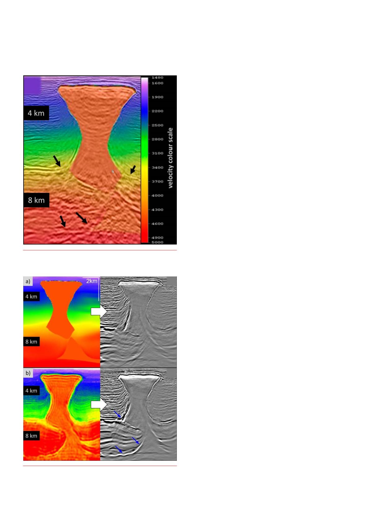
Figure 1.
Marine towed-streamer data. Conventional velocitymodel
superimposedwith the generated image. Arrows indicate unresolved
imaging challenges.
Figure 2.
OBNdata. Velocitymodel on the leftandgenerated image on
the right for a) conventional velocitymodel buildingandb) TL-FWI. Blue
arrows indicate the imagingbenefits.